


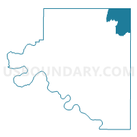
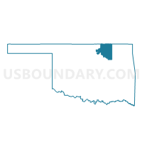
Voting District 101, Osage County, Oklahoma
About
Outline

Summary
| Unique Area Identifier | 654907 |
| Name | Voting District 101 |
| County | Osage County |
| State | Oklahoma |
| Area (square miles) | 103.40 |
| Land Area (square miles) | 97.49 |
| Water Area (square miles) | 5.91 |
| % of Land Area | 94.28 |
| % of Water Area | 5.72 |
| Latitude of the Internal Point | 36.92341790 |
| Longtitude of the Internal Point | -96.08282160 |
Maps

Graphs
Select a template below for downloading or customizing gragh for Voting District 101, Osage County, Oklahoma


Neighbors
Neighoring Voting District (by Name) Neighboring Voting District on the Map
- Voting District 102, Osage County, OK
- Voting District 109, Osage County, OK
- Voting District 114, Osage County, OK
- Voting District 71, Washington County, OK
- Voting District 73, Washington County, OK
- Chautauqua Voting District, Chautauqua County, KS
- Little Caney Township Voting District, Chautauqua County, KS
- Peru Voting District, Chautauqua County, KS
Top 10 Neighboring County Subdivision (by Population) Neighboring County Subdivision on the Map
- Bartlesville CCD, Washington County, OK (43,070)
- Pawhuska CCD, Osage County, OK (7,532)
- Copan CCD, Washington County, OK (2,163)
- Belleville township, Chautauqua County, KS (569)
- Little Caney township, Chautauqua County, KS (329)
Top 10 Neighboring Elementary School District (by Population) Neighboring Elementary School District on the Map
Top 10 Neighboring Unified School District (by Population) Neighboring Unified School District on the Map
- Dewey Public Schools, OK (5,446)
- Caney Valley Unified School District 436, KS (4,358)
- Chautauqua County Community Unified School District 286, KS (2,496)
- Copan Public Schools, OK (2,048)
Top 10 Neighboring State Legislative District Lower Chamber (by Population) Neighboring State Legislative District Lower Chamber on the Map
- State House District 36, OK (37,155)
- State House District 10, OK (35,320)
- State House District 12, KS (19,460)
Top 10 Neighboring State Legislative District Upper Chamber (by Population) Neighboring State Legislative District Upper Chamber on the Map
- State Senate District 10, OK (76,617)
- State Senate District 29, OK (74,057)
- State Senate District 15, KS (63,117)
Top 10 Neighboring 111th Congressional District (by Population) Neighboring 111th Congressional District on the Map
- Congressional District 1, OK (754,310)
- Congressional District 3, OK (732,394)
- Congressional District 4, KS (720,192)
Top 10 Neighboring Census Tract (by Population) Neighboring Census Tract on the Map
- Census Tract 11, Washington County, OK (5,103)
- Census Tract 9646, Chautauqua County, KS (3,669)
- Census Tract 9400.04, Osage County, OK (2,503)
- Census Tract 10, Washington County, OK (2,163)
Top 10 Neighboring 5-Digit ZIP Code Tabulation Area (by Population) Neighboring 5-Digit ZIP Code Tabulation Area on the Map
- 74003, OK (14,249)
- 74056, OK (5,720)
- 74029, OK (5,128)
- 67361, KS (1,841)
- 74022, OK (1,760)
- 67360, KS (409)
- 67355, KS (213)